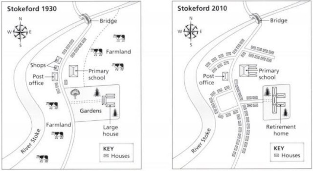
The maps below show the village of Stokeford in 1930 and in 2010. Summarize the information by selecting and reporting the main features, and make comparisons where relevant.
The maps indicate several significant changes in Stokeford village during a period of 80 years.
Overall, it is noticeable that the number of houses increased dramatically, while the lands for agricultural purposes vanished.
In 1930, there were a few houses on both sides of the only road which ran through the middle of the village of Stokeford. By 2010, the local shops had disappeared, and only the Post Office remained. The two areas of farmland to the north-east and south-west were converted into residential areas. Over the same period, more streets were built, leading off the main road to give access to addition housing. Housing was also extended along the main road.
In addition, the local primary school opposite the Post Office was enlarged with two new blocks. The gardens formed the centre of the village in 1930, but by 2010, it was replaced by the housing and the retirement home.
